Search within zoom-kerala.blogspot.com


Sunday, March 23, 2008

Satellite Map of Fort Cochi

This satellite map shifted to following page to improve page load time of home page of blog. You can see these quick loading satellite maps by clicking following link and selecting a place from place selector in that page.
satellite maps of Kerala places

Satellite Map of Cochin International Airport, Nedumbassery

This satellite map shifted to following page to improve page load time of home page of blog. You can see these quick loading satellite maps by clicking following link and selecting a place from place selector in that page.
satellite maps of Kerala places

Satellite Map of Kasargod

This satellite map shifted to following page to improve page load time of home page of blog. You can see these quick loading satellite maps by clicking following link and selecting a place from place selector in that page.
satellite maps of Kerala places

kasarkod beach

bakel fourt watch post, a long view

kasargod beaches: near to bakel fourt

an exciting view of a beach in kasargod
Images courtesy to nice guys who are willing to share their experience at Flickr
Technorati Tags: ,

Satellite Map of Bakel Fort

This satellite map shifted to following page to improve page load time of home page of blog. You can see these quick loading satellite maps by clicking following link and selecting a place from place selector in that page.
satellite maps of Kerala places

Mangalore Satellite Maps

Even though Mangalore is not in Kerala, people in north of Kerala has a friendly relation with Mangalore (Mangaluru). So this time I am posting Mangaluru Satellite Maps.
Note: This satellite map shifted to following page to improve page load time of home page of blog. You can see these quick loading satellite maps by clicking following link and selecting a place from place selector in that page.
satellite maps of Kerala places

A web site for providing Images, Videos about Kerala, Kerala people, Kerala Tourism

My friends new web site provides Images and Videos of Kerala, Kerala people, Kerala Tourism, Kerala Entertainment, Kerala Actors, Kerala Actress etc. Visit this site. Brand new website I guarantee.

Friday, March 14, 2008

Technology Info: Google Street View of Golden Gate Bridge

Dear Readers, Normally in this blog, I used to post subjects related with Kerala only. But I felt as if since I used to post lots of Google maps, I have to give introduction about a new Google map related technology too. It is Google's Street view.Which gives a feeling as if you are walking through these streets. You can see the 360 degree panoramic view from the position you are staying. That means by using mouse or keyboard arrow keys you can see the 360 degree surrounding view from the position of view.

Enjoy following view of Golden Gate bridge, San Francisco in USA.

Please comment on this post if you enjoy. Your comments are great motivation for me, and please bookmark this blog, come back again for similar technology stuff, useful tools, difficult to locate info, because the information here is unique.


View Larger Map

Use mouse to drag(left click+move mouse) or use keyboard arrow keys to see the 360 degree surrounding view of this place.


Technorati Tags: , ,

Google Street view: Sears Towers ( World's 3rd tallest building)


View Larger Map

Use mouse to drag(left click+move mouse) or use keyboard arrow keys to see the 360 degree surrounding view of this place.


Google street view: View from Manhatton bridge, New york

Use mouse or keyboard arrow keys to see the 360 degree surrounding view of Manhattan .

View Larger Map

Use mouse to drag(left click+move mouse) or use keyboard arrow keys to see the 360 degree surrounding view of this place.


Place where World Trade centre existed, Google street view


style="color:#0000FF;text-align:left">View Larger Map

Use mouse to drag(left click+move mouse) or use keyboard arrow keys to see the 360 degree surrounding view of this place.


Technorati Tags: , ,

Technology Preview: Google street view of Long Beach, Silicon valley, USA


View Larger Map

Use mouse to drag(left click+move mouse) or use keyboard arrow keys to see the 360 degree surrounding view of this place.


Technology Info: Google Street View of Disney Land USA


View Larger Map

Use mouse to drag(left click+move mouse) or use keyboard arrow keys to see the 360 degree surrounding view of this place.


Technorati Tags: , , ,

Monday, March 10, 2008

Satellite Maps of Infopark cochin, Smart city Cochin, Kerala, India

Satellite maps of plot selected for so coming Dubai smart city,Cochin, Kerala is posted below. You can see the Cochin info park also in the Satellite map besides to Dubai Internet Smart City plot. Cochin Smart city project, Info Park cochin are located in Kakkanad.Cochin Info park is major destination of most IT companies in Eranakulam now, the addition of Cochin Smart City project to it adds glitter to Kakkanad and Cochin.

I am adding a 
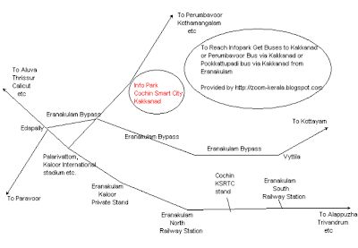
route map to Smart city/Info park/Kakkanadbelow it, help it will be useful for any visitors to these places.To Reach Infopark Get Buses to Kakkanad or Perumbavoor Bus (via Kakkanad) or Pookkattupadi bus (via Kakkanad) from any of Eranakulam bus stops. For those people who are coming via train can get buses from Eranakulam south railway station too.

In an earlier post I have given Satellite map of proper Kakkand, Kakkanad civil station etc.


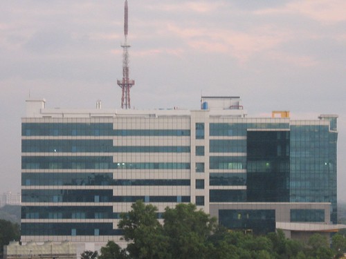
image of Technopolis kakkanad


cochin Infopark,dubai internet city, kakkanad routemap

Technorati Tags: , , , , ,

Saturday, March 8, 2008

Road map of Thiruvananthapuram

To see Satellite maps of Trivandrum please click here

This route map shows Thampanoor and nearby places. You can see KSRTC bus stand, east fort private stand etc.


This route map shows Thiruvananthapuram as a whole


This route map shows Kazhakkoottm, Kariavattom, technopark centered around Technopark


This route map shows places near Palayam, museum, MLA quarters, stadium etc.


palayam

Route map of Eranakulam City, major Roads and Places

One of this blog's all time favorite page is Satellite maps of Eranakulam Marine Drive. See it by clicking here

Following image depicts eranakulam route map centered around Kaloor International stadium. You can trace eranakulam north railway station and Kaloor private stand too here. From Kaloor stand it is get buses to Munnar, Idukki, Perumbavoor, Kothamangalam, Piravam, Thrippoonithura, Fort Kochi etc.
/>
Following route map involves eranakulm city, major roads, rail route etc.
satelliteimageofkalpettacalicutbangaloreroad
Following route map depicts near by places near Eranakulam and cochin and road to them
satelliteimageofkalpettacalicutbangaloreroad